

NORFOLK, Va. — The 13News Now Weather Team has issued a Weather Alert Day starting at noon Friday and continuing through 8 p.m., due to the potential for severe weather.
Follow our coverage here of the weather impacts Helene's outer rain bands are having on Hampton Roads and northeast North Carolina.
8:00 p.m. — Tornado Watch expires
After being extended by two hours, the National Weather Service allowed the Tornado Watch for the Hampton Roads area to expire at 8 p.m.
No other watches or warnings are in effect, so today's Weather Alert Day has officially ended.
6:54 p.m. — Spectrum internet service down across the southeast
The town of Smithfield in Isle of Wight County reported a major outage of Spectrum internet service potentially due to damage sustained to a major hub in South Carolina and to one of their major fiber optic lines.
They do not have an anticipated restoration timeline.
6 p.m. — Tornado Watch extended for coastal Virginia, North Carolina
The National Weather Service has extended a Tornado Watch until 8 p.m. for the Hampton Roads region and northeast North Carolina.
In North Carolina, Camden, Chowan, Currituck, Gates, Pasquotank and Perquimans are included.
In Virginia, areas impacted include Chesapeake, Hampton, Newport News, Norfolk, Poquoson, Portsmouth, Suffolk, Virginia Beach, Williamsburg, Isle of Wight County, James City County, Surry County and York County.
5:38 p.m. — Tornado Warning in areas on the Peninsula
The National Weather Service has issued a Tornado Warning until 6 p.m. for parts of Newport News, York County, James City County and Surry County.
Christopher Newport University told students to seek shelter immediately in relation to this advisory.
5:30 p.m. — Tornado Warning in Chesapeake, Suffolk, Isle of Wight
The National Weather Service has issued a Tornado Warning until 6 p.m. for Chesapeake, Suffolk and Isle of Wight County.
5:15 p.m. — Temporary evacuation order issued at Virginia Beach boardwalk
City officials issued a temporary evacuation order at the Virginia Beach boardwalk, due to lightning within a 10-mile radius. Organizers of the Neptune Festival say the festival will resume after the lightning has cleared.
5:15 p.m. — Flash Flood Warning issued
A Flash Flood Warning has been issued until 8:15 p.m. for a number of areas in and around Hampton Roads.
Areas included are: Charles City County, Gloucester County, Isle of Wight County, James City County, Surry County, York County, Chesapeake, Hampton, Newport News, Norfolk, Poquoson, Portsmouth, Suffolk, Virginia Beach and Williamsburg.
5 p.m. — Neptune Fest adjusts schedule, due to weather
A city event organizer said Neptune Festival will still kick off Friday, just with a little delay and a few adjustments to the planned activities, due to the inclement weather.
Concerts now will begin at 7 p.m. Friday. And Poseidon's Playground activities are canceled for Friday night, but will return Saturday and Sunday.
All other Neptune Festival events will happen, as scheduled.
5 p.m. — Tornado Warnings issued
The National Weather Service has issued a Tornado Warning until 5:30 p.m. for Gates County in North Carolina and Suffolk in Virginia.
4:30 p.m. — Tornado Warning issued for southeast VA counties
The National Weather Service has issued a Tornado Warning until 5 p.m. for areas in southeast Virginia: Sussex, Surry, Isle of Wight and Southampton.
4:23 p.m. — Tornado Warning issued for northeast NC counties
The National Weather Service in Wakefield has issued a Tornado Warning until 5 p.m. for several counties in northeast North Carolina: Bertie, Hertford and Gates.
4:07 p.m. — Tornado Warning issued for Southampton County
The National Weather Service in Wakefield has issued a Tornado Warning for east central Southampton County in southeastern Virginia until 4:45 p.m.
At 4:07 p.m., radar indicated a severe thunderstorm capable of producing a tornado was located over Hunterdale, or near Franklin, moving north at 20 mph, according to the NWS alert.
4:19 p.m. — Flash Flood Warning expanded
A Flash Flood Warning for parts of northeastern North Carolina was expanded and extended until 7:30 p.m.
The areas included in the warning include Bertie, Gates, Hertford and Northampton counties in North Carolina, as well as Suffolk, Franklin, Southampton and Isle of Wight in southeast Virginia.
2:40 p.m. — Flash Flood Warning issued
A Flash Flood Warning is in effect until 5:45 p.m. for Bertie County and central Northampton County in northeastern North Carolina.
The National Weather Service said Doppler radar indicated thunderstorms producing heavy rain in those areas, and between 1 and 2 inches of rain had already fallen.
"The expected rainfall rate is 1.5 to 2.5 inches in 1 hour. Additional rainfall amounts of 1.5 to 2.5 inches are possible in the warned area. Flash flooding is ongoing or expected to begin shortly," the NWS alert said.
2:35 p.m. — Tornado Warning issued for Northampton County, N.C.
The National Weather Service has issued a tornado warning until 3 p.m. for northeastern Northampton County in northeastern North Carolina.
Radar indicated a severe thunderstorm capable of producing a tornado was located 8 miles northwest of Rich Square, moving northeast at 20 mph, NWS said.
2:11 p.m. — Severe Thunderstorm Warning issued
The National Weather Service has issued a severe thunderstorm warning until 3:15 p.m. for areas in northeast North Carolina and southeast Virginia.
Locally, areas included are: Bertie, Northampton, Hertford, Greensville, Emporia, Southampton, Sussex.
At 2:20 p.m., radar indicated that "severe thunderstorms were located along a line extending from near Dahlia to near Scotland Neck to near Bethel, moving northeast at 35 mph," the NWS alert stated.
2 p.m. — Helene downgraded to tropical depression
In the National Hurricane Center's 2 p.m. update, Tropical Storm Helene was downgraded to a tropical depression.
Helene is still producing "historic and catastrophic flooding" over portions of the Southeast and southern Appalachians, the NHC advisory said.
12:19 p.m. — Downed power line blocks Centerville Turnpike
Chesapeake Public Works said on social media that Centerville Turnpike is closed at the Centerville Turnpike Bridge, due to a downed power line across the roadway.
Traffic signals are also non-operational at the intersections with Butts Station Road and Mount Pleasant Road.
The city said that Dominion Energy crews are on the way to clear the downed power line and they are not sure how long that will take.
In the meantime, police are directing traffic and the city is trying to get the traffic signals operating on generator power.
12 p.m. — After-school activities canceled in Suffolk and Newport News
In Newport News, the city's school division has rescheduled the Friday night Woodside vs. Heritage football game at Todd Stadium to Saturday at 11 a.m., due to expected heavy rain. That means Saturday's Hampton vs. Denbigh game will be moved to 4 p.m., a school division spokeswoman said.
In Suffolk, all after-school athletics and activities planned for Friday are canceled. That includes the “Once on This Island” play performed by CPPA at Lakeland High School. A second performance on Saturday is still happening, and anyone with Friday tickets can attend.
Schools in Virginia Beach, Hampton and Portsmouth are operating on a normal schedule.
11:35 a.m. — Suffolk cancels community concert
Suffolk announced the cancelation of its TGIF Fall Concert Series event planned for Friday night, due to expected inclement weather.
The city's Parks & Recreation department said the series would continue in October with an additional concert at the Downtown Festival Park, featuring Slapnation.
10:52 a.m. — Some NC schools closed on Friday
Elizabeth City-Pasquotank Public Schools said classes would be canceled Friday, due to the possibility of severe weather resulting from Hurricane Helene.
8:05 a.m. — Tornado watch issued for coastal Virginia, North Carolina
The National Weather Service has issued a Tornado Watch until 6 p.m. for the Hampton Roads region, northeast North Carolina and adjacent coastal waters.
Twenty-four counties in Virginia are part of the watch, including these areas in Hampton Roads: Chesapeake, Emporia, Franklin, Hampton, Newport news, Norfolk, Poquoson, Portsmouth, Suffolk, Virginia Beach, Williamsburg, Greensville, Isle of Wight, James City, Southampton, Surry, Sussex, and York.
Nine counties in North Carolina are included, as well: Bertie, Camden, Chowan, Currituck, Gates, Hertford, Northampton, Pasquotank and Perquimans.
Weather Alert Day Friday for potential sever weather
A period of showers and isolated heavier tropical downpours are anticipated Friday afternoon across northeast North Carolina and southeast Virginia, as Hurricane Helene's center is set to pass by hundreds of miles to our southwest and west.
While some areas in Hampton Roads may not see a tremendous amount of rain, rainfall totals between .25" and 1.00" are expected, with locally higher amounts possible.
There is a Slight (Level 2) risk of severe weather across southeast Virginia and northeast North Carolina. Smaller, isolated short-lived tornadoes may develop in heavier squalls.

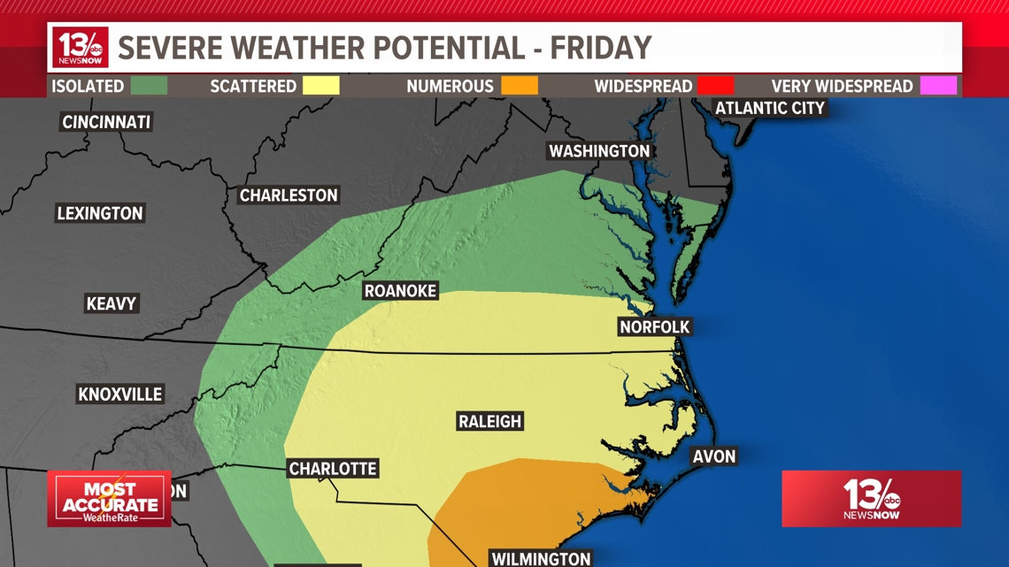
SEVERE WEATHER & TORNADO THREAT
The severe weather threat for Friday is Level 2 for southeast Virginia and northeast North Carolina. There is a level 1 threat for areas north of Hampton, into the Peninsula and Eastern Shore. With some of the locally heavy cells expected to push through the region, there is a risk of small, short-lived, spin-up tornadoes.
Whenever a tropical system moves onto land, it can lead to increased wind shear within the atmosphere, which creates a conducive environment for tornadoes. Luckily the threat is not very high, but the threat does exist Friday afternoon.
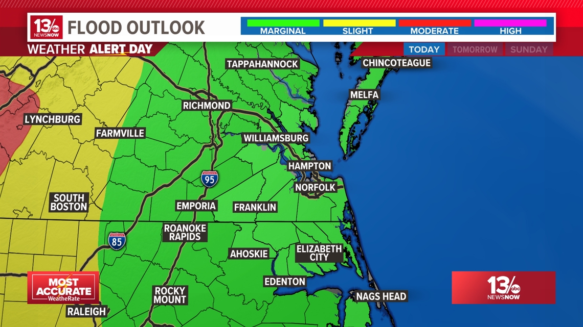
Emergency managers in Virginia and North Carolina will need to monitor central and western parts of the states as the likelihood of flooding is greater in those areas.
FLASH FLOODING POTENTIAL
The time of greatest concern for heavy downpours is between noon and 8 p.m. on Friday.
Helene is moving through north through Georgia. The center is then expected to turn toward the northwest and eventually to the west.
The system will weaken as it moves over land, but it is expected to produce very heavy rain for much of the southeast United States and over the Tennessee River Valley. The mountains of North Carolina will likely see flooding rain. Heavy rain is also possible over western Virginia and the Piedmont as well.
Models project a large band of heavy precipitation will swing out from the center of the system and push through northeast North Carolina and southeast Virginia on Friday. The exact threats and impacts will be determined by how things evolve after Helene makes landfall. A track shift farther west or east could significantly affect what we see in the Mid-Atlantic region.

Stay tuned to 13News Now for updates!