
NORFOLK, Va. — Editor's note: 13News Now's updates of Tropical Storm Idalia have moved to a new story. Click or tap here for the latest.
North Carolina Gov. Roy Cooper said Wednesday that officials are ready to respond as Tropical Storm Idalia is expected to move through the state Wednesday and Thursday, bringing severe weather with it.
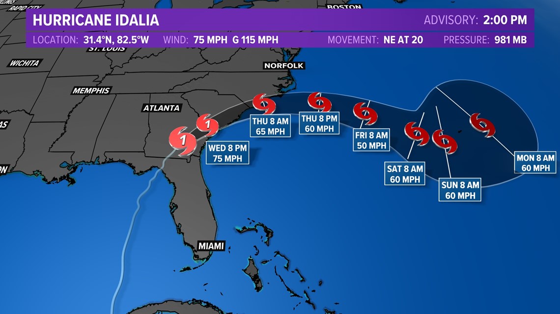
The storm is expected to impact the state Wednesday evening into Thursday, especially the southeastern part with heavy rain and flooding. Tropical storm force winds are possible along the Outer Banks and expected farther south. The storm made landfall Wednesday morning on Florida's Big Bend as a Category 3 hurricane and is currently over South Carolina as a tropical storm.
The National Weather Service issued a Tropical Storm Warning for the Outer Banks and other nearby coastal areas, meaning tropical storm-force winds are expected within the area within the next 36 hours.
On Monday, Cooper declared a state of emergency to activate North Carolina's emergency operations plan, waive rules to help the transport of fuel and critical supplies and services, help first responders and help the agriculture industry get ready, and protect people from price gouging.
Follow 13News Now's coverage as the storm moves through North Carolina:
5:30 a.m. Thursday — The latest on Idalia in North Carolina
13News Now's updates of Tropical Storm Idalia have moved to a new story. Click or tap here for the latest.
9:43 p.m. Wednesday — Coastal Flood Warning issued in Virginia Beach
The National Weather Service issued a Coastal Flood Warning for Virginia Beach Wednesday night. It will last from 6 a.m. Thursday until Friday at 2 p.m.
Up to two feet of inundation above ground level is expected in low-lying areas near shorelines and tidal waterways, the warning said. Widespread flooding is expected, as well as life-threatening rip currents and large breaking waves.
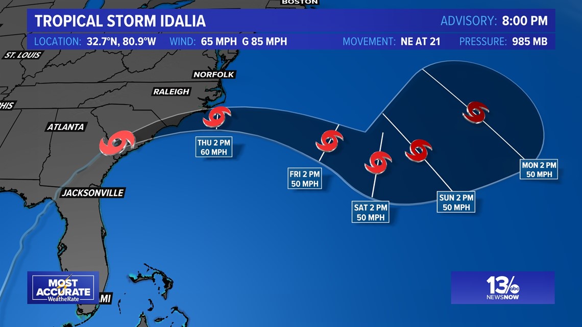
In the National Hurricane Center's 8 p.m. update, Idalia's center was moving over Southern South Carolina, west of Charleston.

7:55 p.m. Wednesday — Tornado Watch issued for parts of North Carolina
The National Weather Service Newport/Morehead City issued a Tornado Watch Wednesday evening for parts of North Carolina until 4 a.m. on Thursday.
5 p.m. Wednesday — Idalia downgraded to tropical storm
In the National Hurricane Center's 5 p.m. update, Idalia was downgraded from a Category 1 hurricane to a tropical storm.
The storm's center is currently moving over southeastern Georgia toward South Carolina with maximum sustained winds of 70 miles per hour.
4:25 p.m. Wednesday — More ferry services on Outer Banks, coastal areas suspended
The ferry division of the North Carolina Department of Transportation has suspended more ferry services on the Outer Banks and in other coastal areas.
After Wednesday night's runs, the Southport, Cherry Branch, Pamlico River and Pamlico Sound routes will stop. The Hatteras-Ocracoke route will suspend service after the 4:30 a.m. departure from Ocracoke on Thursday.
4 p.m. Wednesday — Several Hurricane Idalia school closures in northeastern North Carolina
As Hurricane Idalia moves closer, several school systems and colleges in northeastern North Carolina are announcing schedule changes.
Elizabeth City-Pasquotank Public Schools will have a remote learning day on Thursday and all school facilities will be closed for students and staff.
Currituck County Schools will be closed on Thursday and Friday. Students at JP Knapp Early College will have a remote learning day on Thursday and no school on Friday.
All College of The Albemarle campuses will be closed Thursday and all classes and activities are canceled.
Schools in Camden County, Gates County and Bertie County will be closed Thursday. Dare County schools will be remote learning on Thursday.
3:30 p.m. Wednesday — North Carolina Gov. Roy Cooper, emergency officials give an update
North Carolina Gov. Roy Cooper and other state officials gave an update Wednesday afternoon on their efforts to respond to Hurricane Idalia.
Cooper started off his update by saying he spoke with President Joe Biden an hour before and FEMA Director Deanne Criswell the day before, stressing federal support in responding.
"It's important to coordinate with our federal partners in times like this," Cooper said. "We're hoping for the best but preparing for the worst."
He said Idalia will likely be "near tropical storm strength" when it moves through North Carolina, with heavy rain and localized flooding being the biggest threats in the southeastern part of the state. Five to eight inches of rain are expected east of Interstate 95 Wednesday evening into Thursday.
He encouraged people to stock up on supplies, listen to weather alerts and stay off flooded roads. He said first responders are stationed across the state, the National Guard is on standby to deploy if and when they are needed, and swiftwater rescue teams are prepared in the eastern and central parts of the state.
Cooper added that power outages are expected and officials are working with utility companies to quickly respond. The North Carolina Department of Transportation (NCDOT) is also on standby to clear roadways.
"We expect winds, rain and flooding to continue to impact our state, even into Saturday," Cooper said, advising people to listen to emergency officials, have a plan if they live in an area with a flood risk and prepare an emergency kit.
North Carolina Emergency Management Director William Ray also offered his remarks, saying the state's emergency response team was fully activated Wednesday morning.
"We will remain in 24-hour operations until the threat from Hurricane Idalia has passed," Ray said. "Our concerns for this event are widespread heavy rains with localized flash flooding and moderate riverine and coastal flooding, along with increased tornado and severe weather threat."
When asked about what tourists on the Outer Banks can expect, considering the Labor Day holiday weekend, Cooper encouraged them to be careful by staying inside and off the roads.
"Hopefully, if we get through this, [the visitors] can still have a weekend that will be positive, but until the storm has passed, everybody needs to be careful and stay safe," Cooper said.
2:45 p.m. Wednesday — The latest forecast

2 p.m. Wednesday — National Park Service facilities on Outer Banks closed Thursday
All facilities at Cape Hatteras National Seashore, Fort Raleigh National Historic Site and Wright Brothers National Memorial will be closed Thursday due to Idalia, the National Park Service (NPS) said.
Once post-storm assessments are done, facilities at the three parks will reopen to the public.
NPS officials are encouraging people to avoid driving on North Carolina Highway 12 within Cape Hatteras National Seashore during high tide, the mornings and evenings. The road could have hazardous conditions, including blowing sand, ocean overwash and flooding from the rainfall.
12:50 p.m. Wednesday — Dare County emergency management director talks Idalia response
Dare County Emergency Management Director Drew Pearson talked to 13News Now about what to expect from Idalia, especially on Hatteras Island in North Carolina.
12 p.m. Wednesday — Dominion Energy prepares for Idalia impacts in southeast Virginia, northeast North Carolina
Dominion Energy is preparing for potential power outages as Hurricane Idalia moves through North Carolina on Wednesday evening and Thursday.
In a news release Wednesday, Dominion said it has moved crew members, vehicles and equipment to the area in response to the storm. The power company also said it is communicating with neighboring utility and contract companies to get additional resources if needed.
11:30 a.m. Wednesday — North Carolina insurance commissioner urges storm preparedness
In a news release late Wednesday morning, North Carolina Insurance Commissioner Mike Causey offered tips to people whose homes and property could be vulnerable to storm damage.
“I want to encourage the state’s residents to make necessary preparations now and brush up on helpful tips, which include making an inventory of important belongings and knowing what is in your policy,” Causey wrote. “Our insurance industry is robust and in the best shape it has ever been. Agents are well prepared for the onslaught of claims that may be coming in, and that, once paid, will keep residents’ homes, property and lives intact.”
He also encouraged people to be on the lookout for potential scams.
“If you’re asked to sign anything on the dotted line, stop and ask yourself first if the company is reputable and if this could be a scam,” Causey wrote. “Unfortunately, scam artists use emergency situations such as a hurricane to prey on citizens during vulnerable times. Make sure you keep your guard up so that you don’t get ripped off.”
For more information, visit www.ncdoi.gov/disaster or call the Department of Insurance Consumer Division at 1-855-408-1212.
11 a.m. Wednesday — North Carolina Gov. Roy Cooper, emergency officials to give update at 3 p.m.
North Carolina Gov. Roy Cooper and state emergency management officials will give an update on the government's response to Idalia's impacts at 3 p.m. Wednesday.
9 a.m. Wednesday — Tropical Storm Warning issued for Outer Banks
The National Weather Service issued a Tropical Storm Warning for the Outer Banks and other nearby coastal areas, meaning tropical storm-force winds are expected within the area within the next 36 hours.
Tropical storm force winds are expected to impact much of Hampton Roads with the strongest winds occurring throughout the Outer Banks. Wind speeds of 20-30 mph are expected with wind gusts surpassing 50 mph at times.
In addition, a flood watch is in effect from Wednesday afternoon through Thursday as projected rainfall totals will range from 2-4 inches for North Carolina.
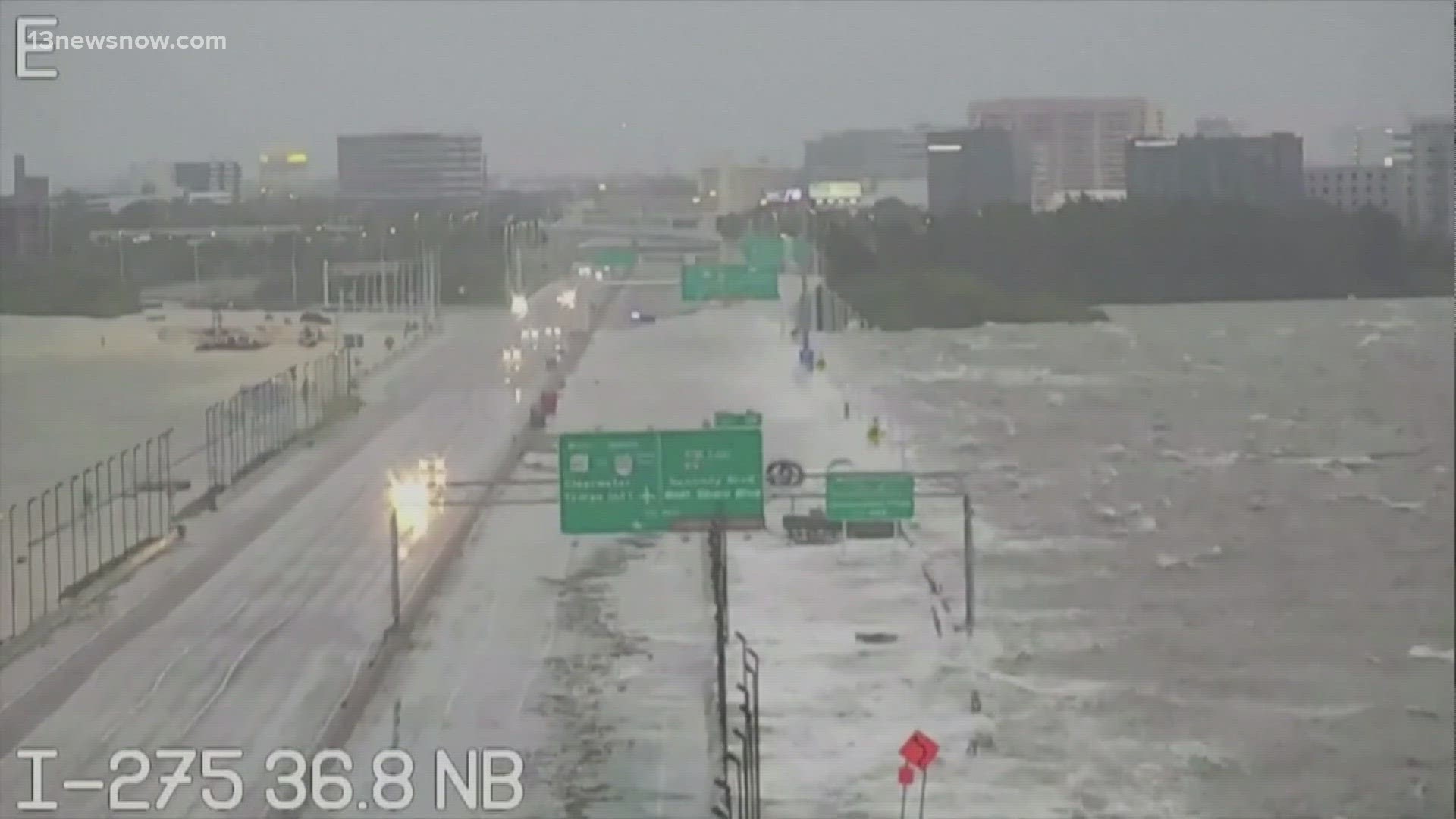
7:45 a.m. Wednesday — Hurricane Idalia makes landfall in Florida as Category 3
According to the Associated Press, Hurricane Idalia made landfall Wednesday in Florida as a Category 3 storm and unleashed devastation along a wide stretch of the Gulf Coast, submerging homes and vehicles, turning streets into rivers, unmooring small boats and downing power lines in an area that has never before received such a pummeling.
11 p.m. Tuesday — Dare County officials call Hurricanes Idalia and Franklin a 'good test' for NC 12
Dare County officials said they're most concerned about the high tide and rough water, and they are calling this week a great test of the millions poured into maintaining North Carolina Highway 12.
Much of that funding has gone towards repairing and maintaining vulnerable portions of the road and building new bridges, like the $154 million Rodanthe Bridge, better known as the 'jug handle bridge.'
10 p.m. Tuesday — Dare County Schools to have remote learning day
Dare County Schools will be having a remote learning day and an optional work day on Thursday and Friday in preparation for Hurricane Idalia's effects.
"The current estimates potentially have us feeling the effects of the storm as early as Wednesday night. As a result, Thursday will be a Remote Learning Day in all of Dare County Schools. Friday will be an Optional Workday, not a student day. Stay safe!"
RELATED: Preparing for Idalia: Dare County Schools won't have students come into school Thursday and Friday
7 p.m. Tuesday — NC 12 overwash reported on Hatteras Island
The Dare County Sheriff's Office said two places along North Carolina Highway 12 on Hatteras Island had ocean overwash Tuesday evening.
The first place was in Rodanthe north of Cross of Honor Way to the old S curves, covering the old northbound lane. The second was in Hatteras Village in the area of Sandy Bay Boardwalk.
3 p.m. Tuesday — Ocracoke Express suspended
The ferry division of the North Carolina Department of Transportation said the Ocracoke Express was suspended Tuesday night ahead of Idalia's arrival.
The department encouraged people to sign up for text and email alerts on its website as other route suspensions are likely.
How North Carolinians can stay safe during Idalia
In a news release from the governor's office, state officials shared several tips to make sure people are ready for the storm and stay safe:
- Have several ways to get emergency information, including watches and warnings. Make sure emergency alerts are enabled on a cell phone and download a weather app.
- Have an emergency plan. If you have to evacuate, know where to go. Make a plan to stay somewhere, and public shelters should be a last resort.
- Gather some emergency supplies or refresh an emergency kit. Visit ReadyNC.gov for information on how to build an emergency kit.
- For those who live near or are visiting the coast, be aware if you are located in a coastal evacuation zone. KnowYourZone.nc.gov will show if you are located in a pre-determined evacuation zone. Learn your zone and listen for it if local governments order evacuations.
- Don't drive through flooded roadways. Turn around, don’t drown.