NORFOLK, Va. —
1 p.m. — No sign of tornado in Suffolk, NWS report says
Jeffrey Orrock with the National Weather Service in Wakefield posted a storm survey report Friday afternoon. He said the NWS surveyed down in Suffolk just north of the NC/VA border, where there appeared to be a potential radar debris signature. However, he said they could not locate any sign of a tornado.
6:40 a.m. — Tornado warning in Suffolk and Isle of Wight County
A tornado warning is in effect for Suffolk and Isle of Wight County until 7 a.m.
6:30 a.m. — Tornado watch in Hampton Road and northeast N.C.
The National Weather Service issued a tornado watch for Hampton Roads and northeast N.C. that is in effect until 7 a.m.
8:15 p.m. — Tornado warnings in northeast N.C.
A tornado warning is in effect until 8:45 p.m. for Southeastern Northampton County and until 9 p.m. for Bertie County in northeastern North Carolina.
At 8:5 p.m., a severe thunderstorm capable of producing a tornado was located over Rich Square, moving north at 25 mph.
6:36 p.m. — Tornado watch extended for entire region
The National Weather Service has extended a tornado watch for the entire Hampton Roads region until 7 a.m. Friday. Areas included in the watch are as follows.
Virginia: Accomack, Chesapeake, Emporia, Franklin, Hampton, Newport News, Norfolk, Poquoson, Portsmouth, Suffolk, Virginia Beach, Williamsburg, Gloucester, Greensville, Isle Of Wight, James City, Southampton, Surry, Sussex, York, Charles City, Essex, King William, King And Queen, New Kent, Mathews, Middlesex, Brunswick, City Of Hopewell, City Of Petersburg, Dinwiddie, Lunenburg, Mecklenburg, Nottoway, Prince George.
North Carolina: Bertie, Camden, Chowan, Currituck, Gates, Hertford, Northampton, Pasquotank and Perquimans.
Much of the eastern half of Virginia and North Carolina are under the same Tornado watch.
6:27 p.m. — Initial storm reports from the NWS
The National Weather Service said there were initial reports from local fire-rescue crews of tropical storm wind damage in the Kings Fork area of Suffolk Thursday evening.
Large trees were reported down on Pruden Blvd, north of Suffolk city limits. Also, two people with minor injuries were reported after a tree fell on a vehicle.
There were also reports of a few trees down on power lines and limbs don in the Corapeake area.
Based on the timing of the damage and radar images from those times, the NWS says it's possible the damage could be related to tornadic activity. But right now, it's too soon to be sure.
5:25 p.m. — Tornado warning in areas west of Hampton Roads
A tornado warning is in effect until 6 p.m. for Prince George County, Sussex County and Surry County.
At 5:25 p.m., a severe thunderstorm capable of producing a tornado was located over Waverly, moving north at 35 mph.
5:04 p.m. — 2 people injured by fallen tree
Suffolk Fire & Rescue said two people had minor injuries around 5 p.m. Thursday when a large tree fell on a moving vehicle.
The fallen tree initially blocked all traffic on Route 58 West at Rt. 460 exit (Pruden Blvd.), according to a social media post by the fire department.
It took crew about an hour and a half to clear the roadway. Suffolk public works, police and fire assisted in the response.
5 p.m. — Debby downgraded to Tropical Depression
In the 5 p.m. update from the National Hurricane Center, Tropical Storm Debby was downgraded to a tropical depression, with maximum sustained winds of 35 mph.
The system, which is about 45 miles East of Charlotte, N.C. and 95 miles west-southwest of Raleigh, still presents a major flood threat for parts of the Carolinas and Western Virginia.
Debby is moving north-northwest at about 17 mph.
4:45 p.m. — Tornado warnings expire across region
Tornado warnings have expired across Hampton Roads and northeast North Carolina. A Tornado Watch remains in effect until 8 p.m. for the entire region.
4:15 p.m. — Tornado warning extended
A Tornado Warning has been extended until 4:45 p.m. for parts of Isle of Wight County, James City County and Surry County.
At 4:11 p.m., a severe thunderstorm capable of producing a tornado was located near Smithfield, moving north northwest at 35 mph.
4 p.m. — Power outages reported in Suffolk
Dominion Energy's online outage map reports 48 customers are without power near Sleepy Hole Park in Suffolk due to a damaged power line. Expected outage until 9 p.m.
3:44 p.m. — Tornado warning issued in Suffolk, Isle of Wight
A Tornado Warning is in effect in Suffolk and Isle of Wight County until 4:15 p.m.
At 3:43 p.m., a severe thunderstorm capable of producing a tornado was located over Kings Fork, or near Downtown Suffolk, moving north northwest at 35 mph.
3:37 p.m. — Tornado warning extended in central Suffolk
A Tornado Warning remains in effect until for central areas in the City of Suffolk.
At 3:37 PM EDT, a severe thunderstorm capable of producing a tornado was located over Kings Fork, or near Downtown Suffolk, moving north northwest at 35 mph.
3:09 p.m. — Tornado warning extended in northeast N.C., Suffolk
A Tornado Warning is extended until 3:45 p.m. for parts of Camden and Gates counties in North Carolina, as well as Suffolk.
3 p.m. — Tornado warning extended in southeastern Virginia
A Tornado Warning is extended until 3:30 p.m. for parts of Suffolk, Isle of Wight County and Southampton County.
2:50 p.m. — Storm damage in Gates County
The Gates County Emergency Management posted a photo on Facebook around 2:30 p.m., showing Silver Springs Road completely blocked due to a fallen tree. North Carolina Department of Transportation told 13News Now they were able to clear the roadway by 3 p.m.
2:40 p.m. — Tornado warnings in effect for local areas
A tornado warning is in effect until 3 p.m. for several areas across Hampton Roads and northeast North Carolina: Isle of Wight, Suffolk, Camden County, Gates County.
1 p.m. — Tornado watch in effect for entire region
The National Weather Service has issued a tornado watch until 8 p.m. for the entire region Thursday. Areas included in the watch are as follows.
Virginia: Chesapeake, Emporia, Franklin, Hampton, Newport news, Norfolk, Poquoson, Portsmouth, Suffolk, Virginia Beach, Williamsburg, Gloucester, Greensville, Isle of Wight, James City County, Southampton, Surry, Sussex, York, Brunswick, Mathews.
North Carolina: Bertie, Camden, Chowan, Currituck, Gates, Hertford, Northampton, Pasquotank, Perquiman counties.
Local Impact from Tropical Storm Debby expected Thursday, Friday:
Debby is now a post- tropical storm, located in southern New York.
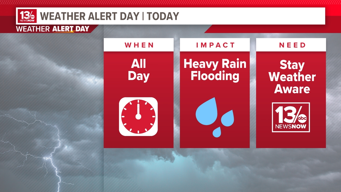
Bands of showers and embedded tropical downpours will persist this through Friday night. These downpours could lead to flash flooding. While heavy rainfall remains a primary concern, we could have wind gusts on Friday as high as 40 mph.
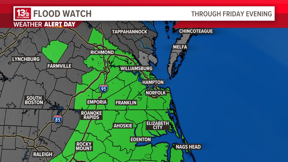
As a result, the 13News Now Weather Team has declared Friday as a "Weather Alert Day" for impacts in Coastal Virginia and North Carolina.

Showers, and tropical downpours, persist Friday as the remnants of Debby push off to the north. We could pick up an additional 1/2 to 2" of rain through early Saturday morning. Expect off-and-on tropical downpours throughout that time. These heavy rainfall rates could lead to flash flooding. So, a Flood Watch is in effect through Friday evening. The heaviest and steadiest rain looks to come to an end late in the day.
Have multiple ways to receive warnings in case of localized or flash flooding.