CEDAR KEY, Fla. — Tropical Storm Debby churns in the Gulf of Mexico as the system is forecast to rapidly strengthen on a track to hit Florida's Big Bend late Sunday or early Monday.
Where is Tropical Storm Debby?
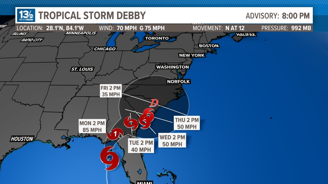
As of 8 p.m. EDT on Sunday:
- Location: 100 miles northwest of Tampa, and 90 miles southwest of Cedar Key, Florida
- Maximum sustained winds: 70 mph
- Movement: N at 12 mph
What is Tropical Storm Debby's projected path?
Debby will continue to head towards the north-northeast Sunday evening, taking aim at the western portions of the Big Bend of Florida. The forward motion of Debby has also started to slow down as she treks northward.
Debby will continue to move over the eastern Gulf of Mexico Sunday evening and overnight, reaching the Big Bend area of Florida early Monday morning as a category 1 hurricane.
After Debby makes landfall in portions of northeastern Florida, the track takes her over the Florida peninsula and back out to the Atlantic Ocean, where she could strengthen into a stronger tropical storm.
Recent models suggest that Debby could stall either over or just off the Atlantic coast of Florida, Georgia and South Carolina. This could bring dangerous flooding to these areas, since the system would not be moving quickly, it would give the storm more time to dump rain. It is predicted that there could be over a foot of rainfall along the South Carolina coastline and for inland areas.
A stalling system could also be dangerous for coastal areas, as the storm has more time to push more ocean water into the area, creating storm surge.

Where is the storm going to hit Florida?
Tropical Storm Debby is expected to continue moving over the eastern Gulf of Mexico Sunday night, reaching the Big Bend of Florida early Monday morning.
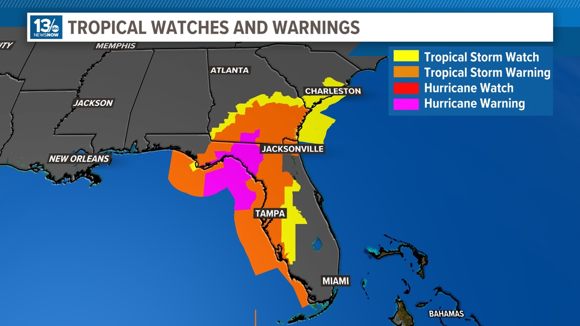
The area within the cone of uncertainty (where the center of the storm is most likely to make landfall) has started to shrink as Debby gets closer to the coastline. The areas along the shoreline within the cone are from Carabelle, Florida to Cross City Florida, along with the state's capital, Tallahassee, which is a bit more inland.
The biggest concerns with Debby along Florida's northeast coastline will be extremely strong gusty winds, up to 90mph or higher, flooding and dangerously high storm surge, which in some areas are expected to be from 6-10 ft.
Tropical storm watches and warnings have been issued for the majority of the eastern coast of Florida, with impacts starting within the next 24 hours. Additionally, a hurricane warning is in effect for parts of the northern Florida Gulf Coast.

Is Tropical Storm Debby a hurricane?
Debby is expected to strengthen into a category 1 hurricane before making landfall with maximum sustained winds of 90 mph, which is stronger than predicted from Saturday's models.
The temperatures in the Gulf of Mexico are extremely warm. For tropical cyclones to strengthen, they need waters to be 80 degrees or above, and the waters where Debby will pass over are around 88 degrees. This gives Debby more than enough energy to strengthen quickly.
There is also little wind shear within the Gulf of Mexico, which also gives the storm a higher chance of growing stronger throughout the weekend.
The storm would become a hurricane if its winds reach 74 mph.
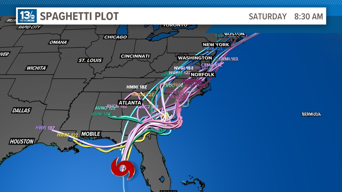
Will Tropical Storm Debbie hit North Carolina?
As of the latest update from the National Hurricane Center, the forecast cone includes much of the state of North Carolina, from the Outer banks to Asheville, along with southern portions of Virginia.
The reason why this forecast cone becomes so large at the end, is because models become less agreeable further out but also, since the system will be moving very slow it also causes models to be less certain of where the center will go.
RELATED: Here's what Hampton Roads, Virginia and northeast North Carolina may see from Tropical Storm Debby
If Debby was to stall off the coast of South Carolina, the most likely scenario (for now) would be Debby eventually making a second landfall along the South Carolina coastline as a tropical storm and eventually head back towards the northeast, over eastern portions of North Carolina and Virginia late next week as a tropical depression. This means that the winds would be 38 mph or less, and the main concern would be rainfall for the Hampton Roads area.
The 13News Now weather team will be monitoring all of this closely. We will be frequently updating the tropical outlooks so check back over the coming days for the latest.