NORFOLK, Va. — After a stretch of dangerously hot days, Coastal Virginia and northeast North Carolina will trade the high heat for heavy rainfall. That rainfall could lead to localized or even flash flooding on Thursday, July 19, 2024.
Follow 13News Now's coverage as we track watches, warnings, and other weather impacts on southeastern Virginia and northeastern North Carolina:
5:15 p.m. — Flash flood warning issued
The National Weather Service in Wakefield, Virginia, issued a flash flood warning until 9:15 p.m. for Chesapeake, Portsmouth and Virginia Beach, as well as Camden, Currituck and Pasquotank counties in northeast North Carolina.
The NWS advisory said that doppler radar indicated thunderstorms producing heavy rain across the warned area, and that 1.5 and 2.5 inches of rain have fallen near the Virginia-North Carolina border in northern Currituck County.
The heavy rainfall is expected to expand across the southern portions of Chesapeake and Virginia Beach during the next hour. Flash flooding is ongoing or expected to begin shortly.
5:05 p.m. — Severe thunderstorm warning issued
The National Weather Service in Wakefield, Virginia, issued a severe thunderstorm warning until 6 p.m. for Norfolk, Chesapeake, Portsmouth, Virginia Beach, as well as Camden and Currituck counties in northeast North Carolina.
3:09 p.m. — Severe thunderstorm warning issued
The National Weather Service in Wakefield, Virginia, issued a severe thunderstorm warning until 4 p.m. for several areas in southeaster Virginia, as storms approach the region.
Those areas include: Greenville County, Emporia, Southampton County, Sussex County, and Brunswick County.
2:30 p.m. — Severe thunderstorm warning issued
The National Weather Service in Wakefield, Virginia, issued a severe thunderstorm warning until 3;15 p.m. for several areas to the west of Hampton Roads, as storms approach the region.
Parts of the following counties and cities were included in the warning: Greensville, Emporia, Sussex, Dinwiddie and Brunswick.
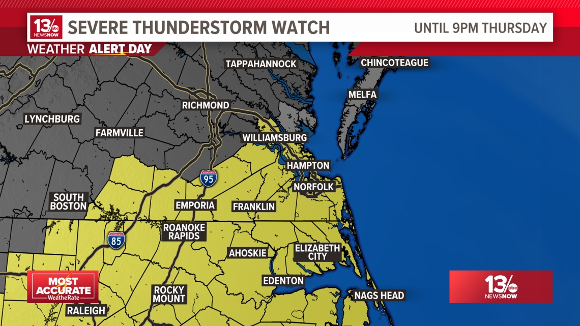
1 p.m. — Severe thunderstorm watch issued
The National Weather Service in Wakefield, Virginia, issued a severe thunderstorm watch until 9 p.m. for whole region, including Hampton Roads and northeast North Carolina.
The watch includes 10 counties and 11 cities in Virginia.
Those are as follows: Chesapeake, Emporia, Franklin, Hampton, Newport News, Norfolk, Poquoson, Portsmouth, Suffolk, Virginia Beach, Williamsburg, Brunswick, Lunenburg, Mecklenburg, Greensville, Isle of Wight, James City, Southampton, Surry, Sussex and York.
The watch includes 9 counties in North Carolina.
Those are as follows: Bertie, Camden, Chowan, Currituck, Gates, Hertford, Northampton, Pasquotank and Perquimans.
The main threat with these storms will be frequent lighting, gusty to damaging winds, hail and torrential downpours.

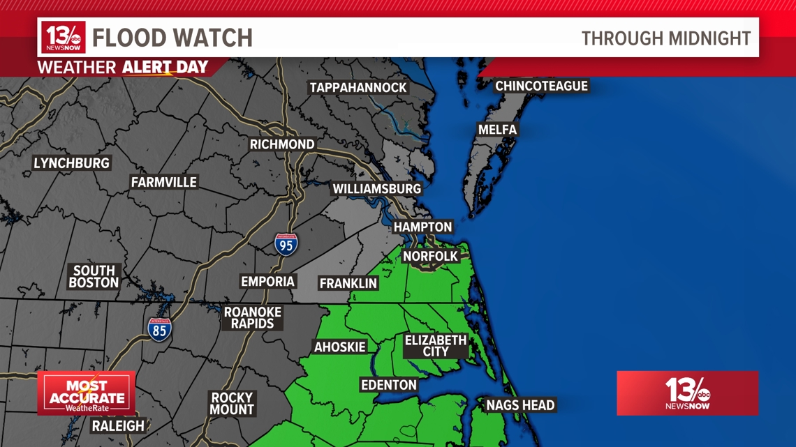
11:30 a.m. — Flood Watches issued
The National Weather Service in Wakefield, Virginia, issued a flood watch that is in effect until midnight Friday, July 19.
The Flood Watch is in effect for parts of northeast North Carolina, including Bertie, Camden, Chowan, Currituck, Gates, Hertford, Pasquotank, and Perquimans counties. The Flood Watch is also in place for southeast Virginia, including Chesapeake, Norfolk, Portsmouth, Suffolk, and Virginia Beach.
Forecasters say excessive runoff may result in flooding of rivers, creeks, streams, and other low-lying and flood-prone locations. Flooding may occur in poor drainage and urban areas.

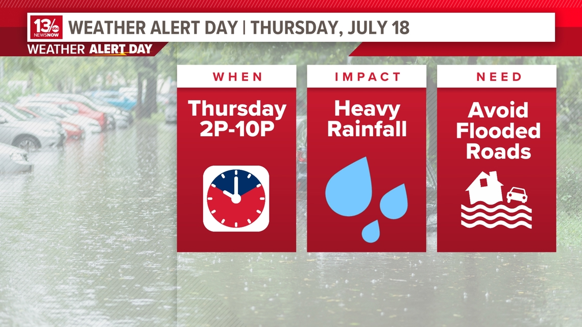
Weather Alert Day:
WHEN
A cold front will approach the mid-Atlantic early Thursday morning, providing opportunities for widespread and heavy rainfall in Hampton Roads and northeast North Carolina. This front will stall in the area, allowing for multiple rounds of rain.
The timing for some of the strongest showers and thunderstorms is between 2 p.m. to 10 p.m. So, the rain will disrupt the evening commute.
The heaviest rain will push south of the area Thursday night, but daily chances for rain will continue into the weekend. Slightly drier air will try to move in Friday.
IMPACT
When heavy rain falls over an area during a short amount of time, flash flooding is more likely. This will lead to standing water or impassable roads. Hampton Roads is already a flood-area so try to avoid places that you know will easily flood.
The highest rainfall totals will pile up in northeast North Carolina, where some places could pick up possibly 4"+ of rain. The majority of the viewing area will see anywhere from 1/2" to 2" of rain.
For the severe threat, the main concern will be frequent lightning, gusty to damaging winds and the possibility for some hail. The tornado threat with these storms will be very low.
NEED
Never drive or walk through flooded roadways. Turn around, don't drown. Also, seek higher ground.
Never play or stand in flood waters. You never know what animals or debris are floating in the water. It only take six inches of flowing flood waters to sweep a person off of their feet.