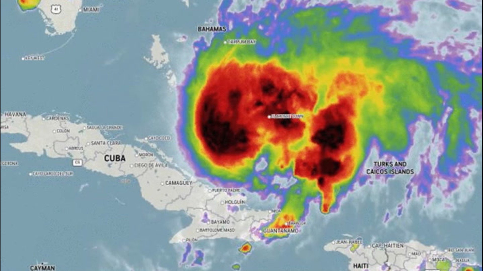
A lull in tropical activity over the Atlantic basin that began right after Isaias's demise on Wednesday is likely to last through this weekend, but the quiet conditions are not likely to last long given 2020's track record.
The Atlantic tropical season has been moving along at a blistering and at times record-setting pace this year. The 2020 season has already spawned nine tropical storms and a tropical depression. Of the nine tropical storms, two -- Hanna and Isaias -- have gone on to strengthen into hurricanes.
The average date for the first hurricane of the Atlantic season is not until Aug. 10.
The 2020 season has left a mark on weather history with storms from Edouard through Isaias setting early-formation records for their respective letter, beating out systems the infamous 2005 season for the title: Emily, Franklin, Gert, Harvey and Irene. Cristobal had also become the earliest "C storm" in recorded history earlier in the season.

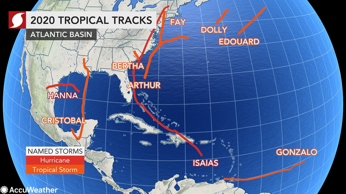
Storms are named in alphabetical order during the season with the list of storms rotated every six years. Not every letter in the alphabet is used with the letters q, u, x, y and z being skipped. Should a season run out of letters of the alphabet, then Greek letters are used. AccuWeather meteorologists expect those Greek letters will be used this year for only the second time on record. The 2005 season was the only year where Greek letters were used. In 2005, six Greek letters were given to name storms: Alpha, Beta, Gamma, Delta, Epsilon and Zeta.
Despite the current lull in tropical activity over the Atlantic, there is a significant chance that the "j" and "k" storms may also set early formation records, both of which were set in 2005. Jose formed on Aug. 22, and the blockbuster Katrina formed on Aug. 24.
"Sea surface temperatures continue to run much higher than normal across the southern part of the Atlantic, much of the Gulf of Mexico and along the southeastern coast of the United States," AccuWeather's top hurricane expert Dan Kottlowski said.
"The very warm water and generally favorable winds in the middle and upper part of the atmosphere are creating lower-than-average surface pressure over much of the Atlantic basin, which in turn has created and will continue to create a favorable environment for tropical development in the long term," Kottlowski explained.
Meanwhile, a train of tropical disturbances, called tropical waves, continues to march westward from Africa. This phenomenon is referred to as the Cabo Verde season, named for the group of islands off the northwest coast of Africa. The Cabo Verde season represents the backbone of the Atlantic hurricane season with most tropical systems from late August through early October stemming from one of these tropical waves.
As of Thursday, there were no organized tropical features across the Atlantic basin with a pause in tropical activity just getting underway.
"Changes taking place this week will be brief but may last into the first part of next week and should limit tropical development over the main part of the Atlantic," Kottlowski said.
"A large high pressure area that usually resides between Bermuda and the Azores is shifting southward this week," Kottlowski said. "In turn, this will cause the belt of northeast trade winds to shift farther south and strengthen into the zone where we have the parade of tropical waves heading westward."

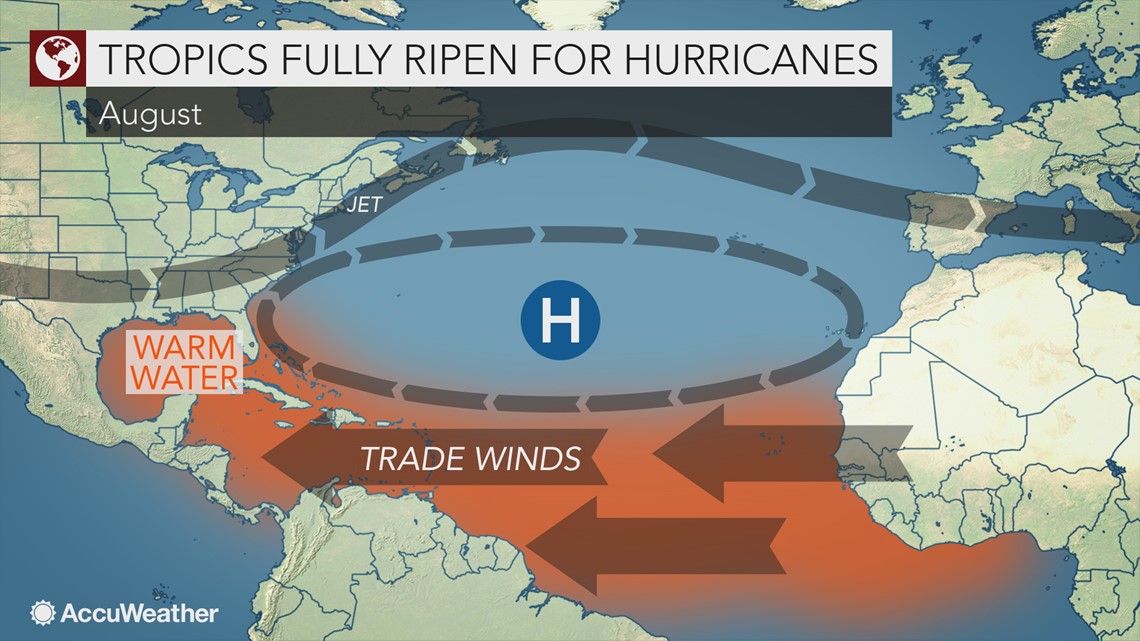
The pattern change will briefly increase wind shear, or the changing of winds with altitude, and the flow of dry air over the zone where many tropical systems are born. Any tropical disturbance, or tropical wave, that moves along through this zone has a high chance of being torn up and any better organized feature would tend to struggle with development.
The chance of development in the Atlantic is not zero, forecasters warned, even in the unfavorable pattern that has recently developed.
"We are watching an area of disorganized clouds and showers a few hundred miles southwest of Bermuda, but chances for development of this system remain very low and on the order of about 10% over the next few days," Kottlowski said.

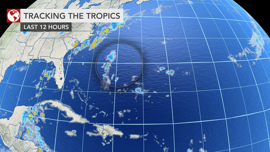
"Moisture associated with the disturbance near Bermuda looks ragged compared to this past weekend, so it has [likely] missed its chance for development," Kottlowski added.
However, the tropical Atlantic's current state, like everything else with the weather, is temporary.
"We expect the high to retreat northward next week and the function of tropical waves moving westward from Africa will have less resistance and will perhaps be more likely to spur development," Kottlowski said.
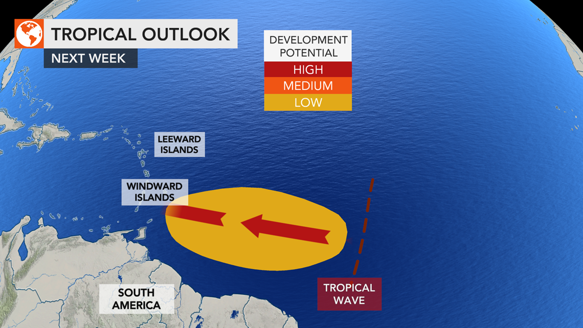
"At some point, perhaps toward the early or middle part of next week, a more robust tropical wave may move westward and could spin something up near the Windward or Leeward islands," Kottlowski added.

In terms of named systems, 2020 has been busier than the entire 2014 season, which spawned only eight tropical storms through the end of October. The first system formed on July 1 in 2014, compared to May 14 of this year.
The peak of hurricane season is not until around the middle of September. The average number of tropical storms and hurricanes typically does not ramp up until the latter part of August, and the tropics tend to stay rather busy through much of October.

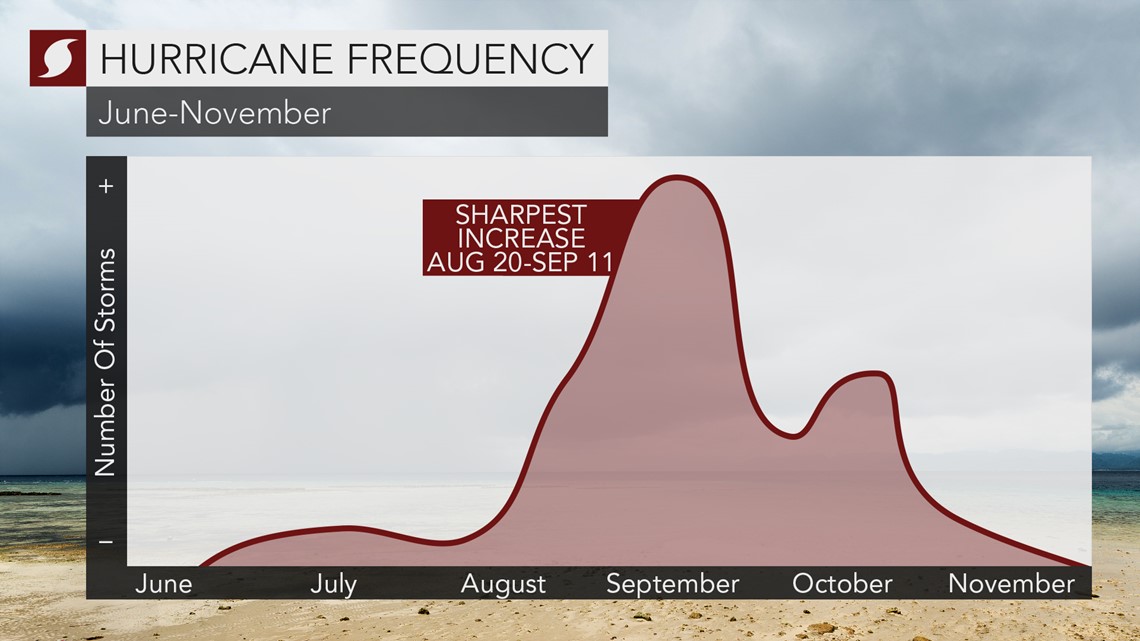
With the heart of hurricane season still looming, it is likely that many more named systems, and especially several more hurricanes, will form. Some of the hurricanes are likely to strengthen further into major hurricanes -- Category 3 strength or greater. And there is the potential for this season to remain active through the end of November, perhaps even into December.
The record for the greatest number of named systems for the Atlantic basin belongs to 2005, when 28 storms occurred. AccuWeather's hurricane experts are projecting the 2020 season to come in at number two in terms of the numbers of named systems, surpassing 19 held by the 1995, 2010, 2011 and 2012 seasons. Each of those years brought at least seven hurricanes and at least two major hurricanes.
The AccuWeather's initial 2020 forecast in March called for 14-18 tropical storms, seven to nine hurricanes and two to four major hurricanes. After a review of new forecasting data in May, projections were increased to 14-20 tropical storms, seven to 11 hurricanes and four to six major hurricanes. At the end of July, the company's experts pushed forecast numbers even higher with up to 24 tropical storms in the latest prediction for the season.

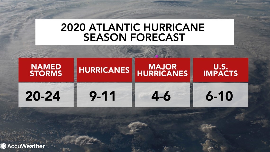
On Thursday, the National Oceanic and Atmospheric Administration (NOAA) issued an update to its 2020 outlook and is now calling for 19 to 25 named storms, seven to 11 hurricanes, three to six of which could strengthen into major hurricanes in an "extremely active" season.
"This is one of the most active seasonal forecasts that NOAA has produced in its 22-year history of hurricane outlooks," said U.S. Secretary of Commerce Wilbur Ross.
On Wednesday, experts at Colorado State University upped their forecast for the number of tropical storms, now 24, and hurricanes, now 12.
A typical Atlantic hurricane season generates 12 named tropical storms, six hurricanes and three major hurricanes.

