NORFOLK, Va. — Author's note: The video above explains climate change's impact on the weather. It was posted on July 27.
Let's be real: For those living in Hampton Roads, flooding can be really annoying.
Aside from the obvious threat to life and property, tidal flooding forces people in the 757 to adjust a bit, like parking a car on a higher level or finding a new route to work.
But if you think it's bad now, it's going to get worse, according to new data from the National Oceanic and Atmospheric Administration (NOAA).
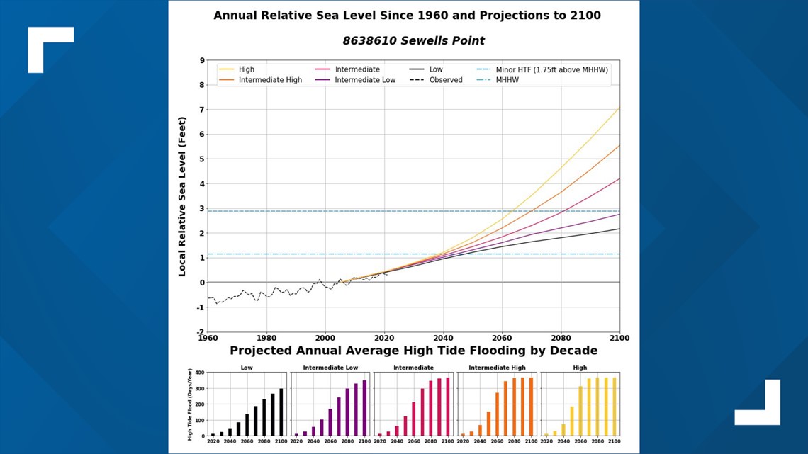
Norfolk could see 85 to 125 days of high-tide flooding by the year 2050, a significant jump from the 10 to 15 days expected in 2022, NOAA data shows.
The agency also found that 2021 had 13 days of high-tide flooding in Norfolk, compared to five in the year 2000.
The measurement came from a tide gauge at Sewells Point, one of 97 along the U.S. coast the NOAA monitored for changes in high-tide flooding patterns between May 2021 and April 2022.


That data was used to provide a flooding outlook for these locations through April 2023 and projections for the next several decades. Norfolk isn't the only place seeing higher tidal flooding, according to NOAA.
Reedy Point, Delaware, saw six high tide flooding days in 2022, one more event than 2021. Also, the water level station at Springmaid Pier, South Carolina, near Myrtle Beach, tied its 2021 record with 11 high tide flooding days.
Not far from Norfolk, Kiptopeke on the Eastern Shore saw nine high-tide flood days in 2021 and is predicted to get 55 to 85 days by 2050.
NOAA attributed the increase in high-tide flooding — also called “king tides,” “nuisance,” or “sunny day” flooding — to decades of sea level rise, which is driven by climate change.
“High tide flooding is becoming more common and damaging in many parts of the U.S.,” NOAA Administrator Rick Spinrad said in a news release. "As part of NOAA’s work to build a Climate-Ready Nation, we will continue to provide coastal communities with the information needed to anticipate, prepare for and respond to increasingly frequent high tide flooding.”
Hampton Roads is especially prone to sea-level rise due to the already low-lying land's subsidence, the slow sinking of land resulting from removing large amounts of groundwater.
While the sinking rate is millimeters a year, subsidence and sea-level rise exasperate flooding when it happens. Flooding poses a threat to several things in Hampton Roads, including military infrastructure, schools, hospitals and people's property, according to sealevelrise.org.
To combat the issue of flooding, Virginia has the Community Flood Preparedness Fund (CFPF) which provides support for regions and localities across Virginia to reduce the impacts of flooding, including flooding driven by climate change.
Also, the state government released the Virginia Coastal Resilience Master Plan in December 2021, which outlined steps for adapting to coastal flooding problems.

